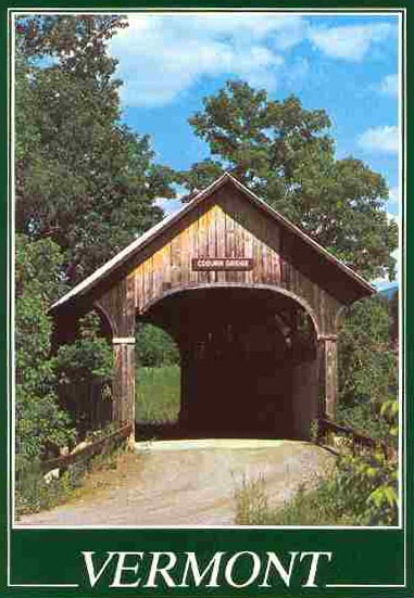
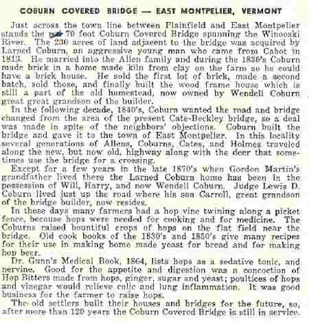
Coburn Covered Bridge
More Than Just A Way to Cross the River
by David A. Coburn ©2004

Drawing by Joan Gaboriault
© David A. Coburn 1999, 2004
Coburn Bridge Presentation Index
- Coburn Bridge Physical Details
- Coburn Bridges Maps
- Coburn Bridge History
- Coburn Bridge is Built
- Coburn Bridge Current Views
- Coburn Bridge Post Cards
- Coburn Bridge Hale Painting
Coburn Covered Bridge: Physical Details
- Carries Coburn Road over the main stem of the Winooski River
- Queen Post framing
- Built in 1851
- 69.5 feet long
- 15 ± feet wide
- 9 feet of clearance
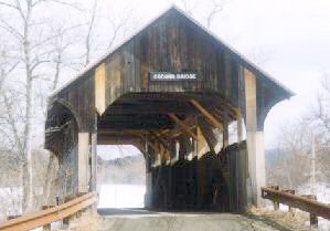
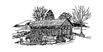
Photo by Elliott Morse
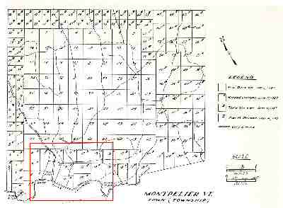
Coburn Covered Bridge: Maps
Large Map
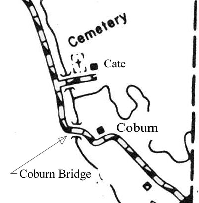
With detail
Bridge Location Map
Coburn Covered Bridge: History
The bridge was built in 1851 by Larned Coburn and given as a gift to the town. The only covered bridge left in East Montpelier, it crosses the main stem of the Winooski River, just down stream from the confluence with the Kingsbury Branch. It is of Queen post design and when built, was almost entirely of wood. During the 150 years that have passed, the bridge has survived the ravages of time, innumerable floods, and several encounters with large vehicles.
Not much of the original bridge survives. A concrete floor on steel beams replaced the wooden deck and supporting timbers in 1974. Extensive reconstruction to the framing was done in 1997. The roof is new, as are many of the outer boards.
The bridge is typical of the many small covered structures that for many years carried the traffic of Vermont over the rivers. Only 70 feet long and certainly not up to modern standards, it is nevertheless a source of local pride and a nice way to get to the other side of the river.
Coburn Covered Bridge: History - Town of Montpelier
Chartered 1781
Sixty years later, a sizable village had grown up near the confluence of the Winooski River and the North Branch. The good folks of Montpelier Village had begun to pave their streets and install a water system. They tended to view the larger rural portion of the town as a "black hole" for tax money for roads, bridges, cemeteries and care of the indigent.
Map shows the original list divisions.
Coburn Covered Bridge: History - Town of East Montpelier
Created 1849
The citizens of Montpelier village petitioned the Legislature to be allowed to form their own town. This was quickly granted and on January 1, 1849, the voters of the new town of East Montpelier had to hold a meeting to elect a complete slate of town officers.
At the Town Meeting in March, the issue of raising taxes and making repairs to the roads and bridges was taken up.
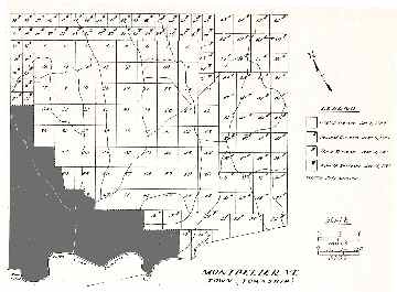
Map shows the location of East Montpelier.
Coburn Covered Bridge: The Bridge is Built
One of the bridges that needed to be replaced was the one that crossed the Kingsbury Branch near the farm of Isaac Cate.
Considerable debate and several votes ensued without any resolution. Finally to settle the issue, Larned Coburn offered to build a bridge and give it to the Town with the proviso that it be located near his house and a road built to pass through it. This was accepted; one might presume, thankfully.
Larned Coburn was born in Cabot in 1800 but came to live with an Allen family in the town of (then) Montpelier when he was 12. He stayed on to marry the Allen daughter, raise a large family and run a prosperous farm. He built the house that is just east of the Coburn Bridge; at that time at the end of the road. The nearest bridge was on the Cate Road -- about half-mile upstream -- but there was no road from Larned's house along along the river to this crossing. Since more than half of his land was on the side of the river opposite his buildings, it meant a long round-about trip to get to these fields.
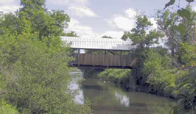
Coburn Covered Bridge: Current Views
Approach from the North
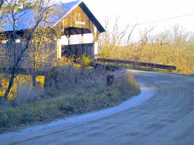
© 2004 David A. Coburn
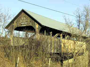
The bridge sits very high over the water, so much so that the road enters and leaves at a very steep angle. This lofty perch is what has enabled it to survive the many floods, including the one in 1927 that removed the vast majority of the other bridges in Vermont.
There is even a ledgend that during one particularly high spring run-off, the Cate Bridge -- then also a wooden, covered structure -- was washed downstream and passed under the Coburn Bridge. It was found high and dry on the riverbank some distance downstream. The thrifty town folk pulled it back into the river, floated it upstream to the Cate Road and reset it on its foundation. (That Cate Bridge is long since gone, replaced several times, most recently by one of steel and concrete.)
South Side
© 2004 David A. Coburn
This view shows the new siding that was aded as part of the reconstruction in 1997. Broken boards in the top of the entry caused by large trucks using Coburn Road as a shortcut between US-2 and VT-14.
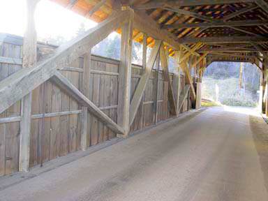
North Wall
© 2004 David A. Coburn
South Wall
© 2004 David A. Coburn
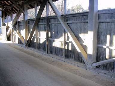
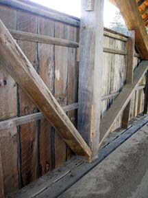
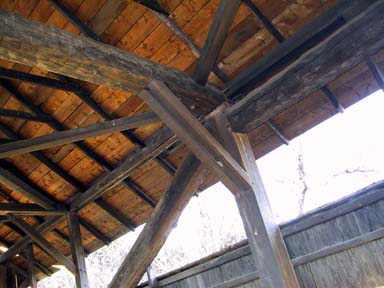
A good View of the queen post construction
Queen Post Detail
© 2004 David A. Coburn
© 2004 David A. Coburn
Roof Structure
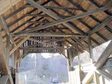
© 2004 David A. Coburn
View from down river
© 2004 David A. Coburn
Coburn Covered Bridge: Post Cards
©Allios Mayer
One of numerous views of the bridge that have found their way into publications over the years.
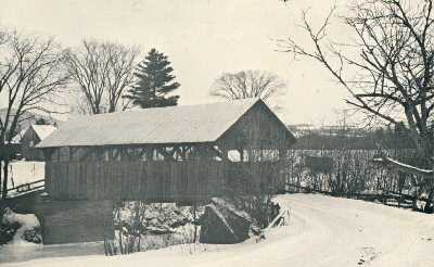
Plainfield Vermont, U.S.A.
c. 1970
Plainfield Vermont, U.S.A.
c. 1970
Information on obverse side of postcard
Coburn Covered Bridge: Hale Painting
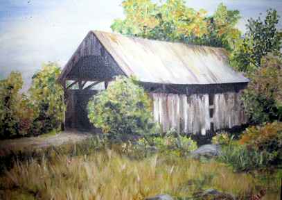
©Aleta Hale
View of the bridge painted by Aleta Hale, at the time a resident of East Montpelier. This was done sometime around 1950 and shows the condition of the bridge before the old wooden deck was replaced by the concrete and steel one.