ENGINEERING STUDY
For the
East Fairfield COVERED BRIDGE
Bridge No. 50
World Guide No. 45-06-03
Town Highway 49
Fairfield, VT
Prepared by: HTA Consulting Engineers, Burlington, Vt.
Prepared for: Vermont Agency of Transportation
The Town of Fairfield, Vt.
April 2006 Revised May 2006
TABLE OF CONTENTS
1. EXECUTIVE SUMMARY
Hoyle, Tanner & Associates, Inc. (HTA) has been assigned, through a retainer contract with the Vermont Agency of Transportation (VTrans), the task of preparing an Engineering Study for the rehabilitation of the East Fairfield Covered Bridge. The project's Priority of Uses as defined by the Historic Covered Bridge Preservation Plan is "Special Use on Roads". This use allows the bridge to remain in use but limits use to very light traffic, primarily cars.
The East Fairfield Covered Bridge was inspected and load rated to determine it's current condition as well as its capacity to support a H6 (6 ton) live load rating. Our rating assumes replacement of deteriorated bridge members, new decking, new bottom chords of each truss and supplemental members added to the truss end diagonals. It was determined that the existing trusses have a live load capacity of approximately H5.7 (5.7 tons) at inventory level and the floor system have a capacity of H5.4 (5.4 tons) at inventory.
Additional items are discussed in this report and recommended for the bridge include a new standing seam metal roof; new siding; substructure repairs and replacement; replacement of deteriorated bridge members; the addition of lighting, fire protection, substructure repairs and replacements, bridge approach railing and lateral bracing; paving of the bridge approaches; and realignment of, the trusses. The total estimated cost of all recommended work items, without contingencies, is approximately $477,750 including contingencies.
2. INTRODUCTION
HTA has been assigned, through a retainer contract with the VTrans, the task of preparing an Engineering Study for the rehabilitation of the East Fairfield Covered Bridge. On November 28, 2005 and November 29, 2005 an Inspection Team from HTA visited the bridge to perform field observations and gather field data for this Engineering Study.
3. BACKGROUND
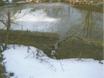
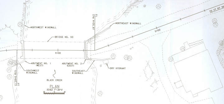
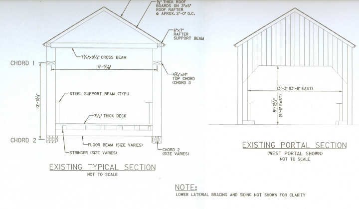
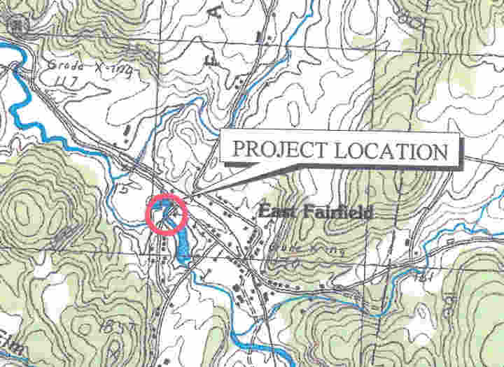
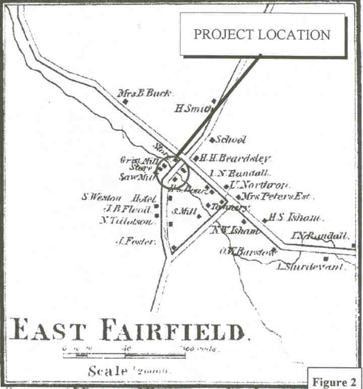
The East Fairfield Covered Bridge is located in the Town of Fairfield, Vermont and was built in about 1865. The bridge's sixty-eight (68') foot single span timber superstructure utilizes Queenpost spaced at 14'-10" on-center (see Appendix C for existing and portal sections and plan view). The bridge runs east to west and crosses over the Black Creek on Town Highway No. 49. It is supported by abutments originally constructed out of large stones. The east abutment has been partially reconstructed and is encased with concrete. The west abutment has been pointed and is constructed out of large stones. The bridge has been closed to traffic since 1991 and is on the National Register of Historic Places.
Upstream Elevation
4. FIELD OBSERVATIONS
On November 28, 2005 and November 29, 2005 an inspection team from HTA visited the bridge to perform in-depth field measurements and gather field data for this Engineering Study. Wright Construction Company was in on-site on November 29, 2005 and provided inspection access to the lower portions of the bridge with a raft. Field observations were used as a basis for this report and expanded as appropriate.
5. WOOD SPECIES IDENTIFICATION
Five (5) small wood samples were removed from the bridge for the purpose of species identification. The samples were taken from deteriorated members that will most likely be replaced during the course of the bridge rehabilitation. The samples were forwarded Doug Gardner, Ph.D., a professor of Wood Science and Technology, at the University of Maine at Orono for identification. From analysis, it was determined that the deck and stringer samples were Eastern Hemlock and the chord sample is Spruce. The floor sample is either Eastern Hemlock or Fir, while the rafter is either Spruce or Fir. It is interesting to note that the rafter sample has 40 growth rings per half inch, which indicates very slow growth. This species evaluation is consistent with historical records that indicate native wood was used during construction. A copy of Dr. Gardner's report is included as Appendix A.
6. HYDRAULICS
The bridge crosses over the Black Creek which runs roughly south to north at the bridge site. At the time of our inspection there was approximately 6-feet of vertical clearance above the water level to the lower chord bottom face elevation of 383 feet.
The VTrans Hydraulics Unit completed a preliminary hydraulic study dated November 7, 2005. The conclusion of the study was that both the Q25 (El 381.4') and Q100 (El 382.4') water elevations were below the low chord elevation of 383-feet. A USGS level II Scour Analysis was also performed with a result of 3.1' of contraction scour at the Q500.
Downstream Elevation
7. STRUCTURAL ANALYSIS / REPLACEMENT RECOMMENDATIONS
A structural analysis was performed of all key members of the bridge superstructure. The Service load (Allowable Stress) design method was used for all members as required by the VTRANS Structure Manual (Chapter 22, Section 22.1). Allowable stress values for wood members were obtained from the 2005 National Design Specification for Wood Construction and Supplement. The wood species used in the superstructure was identified through testing (see Section IV). The grade assigned to each member was based on a visual examination of knots, checks and the growth rate characteristics of the wood. All superstructure members are wood unless noted otherwise.
The condition of each member is detailed in the following sections with our initial recommendations for repair of replacement which must be reviewed by the Historic Covered Bridge Committee (HCBC) and the structural and historical issues weighed. We have also identified in the recommendations for sections 7.1 through 7.5 the priority treatment number from the Historic Covered Bridge Preservation Plan to aid in review.
It should be noted that not all members to be replaced can be identified based on our inspection due to inaccessible areas (top face of rafters, etc.). The contract documents and estimate of cost in this study include an additional amount of conditional replacement where appropriate to determine an appropriate budget for the project.
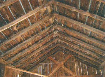
1. Roof Framing
Description: The roof framing consists of metal roofing attached to 7/8" thick roof boards. The roof boards are supported by 3" x 5" rafters spaced at 2'-0" on-center. The rafters are notched into a 7" x 7" rafter support beam which spans wood columns supported on the trusses. The rafter and roof board wood species is Spruce/Fir for analysis and they have been assigned a grading of Select Structural.
Analysis: The roof rafters were analyzed for dead load and a ground snow load of 50 PSF (27.4 PSF roof applied) per the 2005 Vermont Fire and Building Safety Code snow load and the 2000 International Building Code. The rafters and roof boards were found to be adequate for the applied dead and snow loading.
Recommendations: The existing metal roof is in poor condition and we recommend that it be replaced with a new standing seam metal roof. The rafter and roof boards are generally in good condition. We have assumed replacement of six (6) rafters and 30% of the existing roof boards for this study based upon our field inspection. (Priority Treatment Number 2 for the roof boards and 9 for the rafters since local species is select structural will be very difficult to obtain.)
Rafters and Roof Boards
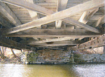
2. Lateral Bracinq
Description: The top lateral bracing consists of 4" x 4" knee braces and nine (9) 7%" x 8W' crossbeams bearing on top of the rafter support beam. The 4"x4" knee braces connect to the cross beams and either a truss vertical or siding support. There are not any diagonal braces between the crossbeams.
The lateral bracing in the bridge is in poor condition and is not adequate to resist code required wind loads. The bridge trusses are racked between 2" and 5" depending upon the location. Damage (tenon pullout) was noted in at least two (2) crossbeams. Some of the crossbeams are supported on rafter support beam columns that bear on the truss. The connection between the column and the truss member is toe nailed which has a very low lateral capacity.
Analysis: The upper lateral bracing is very limited and was, not analyzed for this study since additional lateral bracing is recommended for the bridge.
Recommendations: Due to the poor capacity of the bridge lateral bracing, we recommend additional horizontal 'X' bracing be added between the existing crossbeams and strengthening of the connections of the rafter support beam columns.
The knee braces in the bridge are in fair to good condition and no replacement is proposed. There are ten (10) locations where crossbeams were intended in the bridge. Of these:
- One (1) is in good condition
- One (1) is missing and a new local species member be installed.
- Four (4) have broken tenon connections.
- Four (4) have been modified by adding wood plates to the side. The connection condition is unknown.
Since the crossbeams transfer load to the rafter support beam and the roof rafters transfer a horizontal load to the connections, steel may be required to provide adequate lateral capacity. Specific recommendations will be made at a later date after discussions with the HCBC.
Depending on the lateral bracing decisions made, priority of treatment will be treatment number 2 or 5 for new or replaced crossbeams depending on the member size required and treatment number 7 for rafter support beam connections.
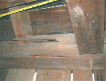
Crossbeam Failed Connection
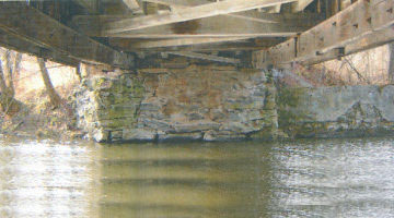
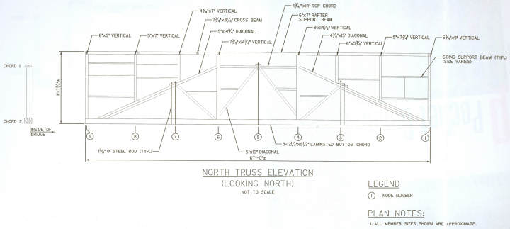
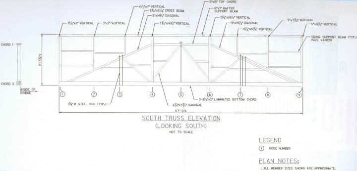
3. Trusses
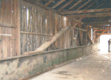
Description: The bridge utilizes Queen Post trusses with the truss members in poor to good condition. They were identified as a Spruce species with a grade of select structural assigned for analysis. Steel beams have been added inside of each truss to help support the bridge due to the poor condition of the truss lower chords.
The upper truss members are in fair to good condition and appear to be original construction. The lower chords are in poor condition with large sag deflection, additional members added at mid-span and added through bolting. Large gaps at chord butt joints and rot were also noted in many locations of the lower chord. Steel straps have also been added at the truss verticals and end diagonals where rot is present or the original mortise and tenon joint is no longer functioning.
Analysis: The trusses were analyzed to determine their current live load capacity. Full dead and live loads were applied and compared to inventory stress levels and full dead, live and snow loads were applied and compared to the higher operating stress level. The following assumptions were made with the truss analysis: 1) the bottom chord is replaced in kind with new members and 2) the end diagonals are supplemented with additional members to increase the live load capacity (a rating of approximately H1 is obtained without this assumption). The live load capacity of the trusses was found to be H5.6 (5.6 tons) at inventory and H5.7 (5.7 tons) at operating both ratings are controlled by vertical member capacity.
Due to the location of the bridge on a low volume Town road with a very short unposted detour and the low vertical clearance of the bridge we have assumed that the bridge will be posted for a live load of H6 (6 tons), which is approximately the truss capacity. Should a higher live load capacity be required, many members of trusses would have to be replaced or strengthened.
Recommendations: The portions of the truss above the bottom chord are in good condition except for the end diagonals where rot was found at the lower end and several large splits in some members. Additional splices/supplemental members are recommended for the end diagonals as discussed above. The existing supplemental members are not considered to be adequate due to their poor connection to the diagonals and insufficient length. Epoxy injection into the larger splits is also recommended to lessen further splitting and insect damage to these members. (Priority Treatment Number 1).
The lower chords of both trusses are in poor condition and full replacement is recommended. The members would be replaced with similar sized members which retain similar joints and detailing. (Priority Treatment Number 9).
South Truss Elevation
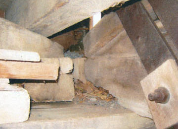
Bottom Chord Rot of Southeast Bearing
North Truss Lower Chord
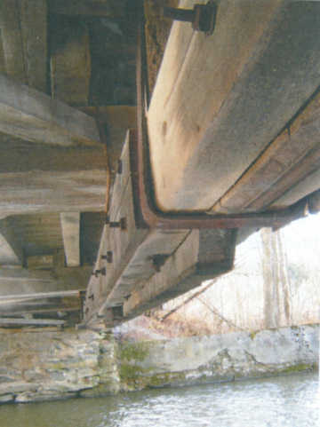
4. Floor Beams, Stringers, and Decking[Existing Deck]
Description: The existing floor framing consists of a 3½" thick plank deck supported by stringers spaced at approximately 2'-8" on center and vary in size from 5" x 7" to 8" x 8". The stringers are supported on multiple piece floorbeams with a total size of 19" wide by 9½" deep. The floorbeam spacing varies but is on average 9' with 3¾" x 5¾" lateral 'x' bracing spanning between floorbeams.
Analysis: The existing floor beams, stringers and decking were analyzed to determine their live load capacity (see Table 1). All three (3) existing components are Eastern Hemlock and were assigned a grade of No.1 due to large knots and wane in the members.
Recommendations: Based upon the low live load capacity and wear in the deck we recommend complete replacement with a new 3W' thick No.1 grade Douglas Fir deck (Priority Treatment Number 9). The live load operating rating of the stringers is H7.3, therefore only replacement of approximately one third of the stringers is recommended due to their condition. The stringer selected for load rating is at the maximum spacing in the bridge while most stringers are at a lesser spacing, which would have a higher capacity. The floor beams are adequate for a six (6) ton live load capacity. We recommend approximately one quarter of the floorbeam board footage be replaced due to condition. We recommend both stringers and floorbeams be replaced with Douglas Fir or Southern Pine since local species in select structural will be very difficult to obtain. (Priority Treatment Number 9).
In addition, we recommend that a new wood curb be added to the bridge to help keep vehicles from impacting the trusses. This curb has previously been used by VTrans on the Union Covered Bridge in Thetford, the Comstock Covered Bridge in Montgomery and the Greenbanks Hollow Covered Bridge in Danville.
Table 1 - Floor Framing Capacities
| Member | Size and Spacing | Load Rating |
| E. Hemlock Deck (existing) | 3" thick, 24" span | H3.0 |
| Doug. Fir Deck (proposed) | 3½" thick, 24" span | H7.3 |
| Stringer | 7½" x 7½", 2-8" | H5.4 |
| Floorbeam | 19" x 9½", 9'-4" | H7.1 |
Floor Framing
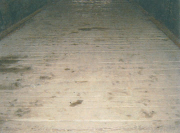
Existing Deck
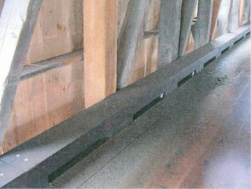
Proposed Bridge Curb
5. Abutments
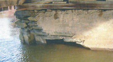
Description: The east abutment was originally constructed out of large stones and the exact depth of the abutment is not known. The east abutment has been partially encased in concrete and a concrete backwall added. Each of the east wingwalls have failed; the southeast wingwall stone section has failed and the northeast concrete wingwall has broken with a large vertical crack. Temporary repairs were made to this wall by bracing it off the southeast wingwall with steel wire rope.
Several large stones are no longer in place in the east abutment breastwall near the base. The stones above the void are bridging the opening and the abutment is relatively stable. This section of the abutment appears to be founded on ledge.
The west abutment and southwest wingwall are constructed out of large stones and are fully pointed with an unknown depth. A concrete backwall has been added to the abutment. The northwest wingwall is a concrete wall which was once part of a mill building at the site (see Appendix E for more information). The west substructure is generally in fair to good condition.
Analysis: The existing abutments were analyzed for overturning and sliding per the VTrans structures manual with an assumed breastwall depth of 5'-0" deep. Two (2) conditions were checked for each abutment. The first condition analyzed the abutments alone with soil loading and no dead load. This condition may occur while the bridge has been removed during construction and the dead load of the bridge is not applied to the abutments. The second condition includes both soil loading and a live load surcharge acting on the abutment without dead load.
We determined that for the first condition, the factor of safety for overturning and sliding met VTrans requirements. For the second condition, both factors of safety were greater than 1.0 but less than VTrans requirements of 1.5 for sliding and 2.0 for overturning. This is considered a temporary condition during construction where a lower factor of safety may be appropriate. When the dead load of the bridge is added to the abutments, they are adequate for dead load earth, pressure and live load surcharge.
Recommendations: The following repair/replacement recommendations are made for the bridge substructure:
- Fill the large void in the east abutment breastwall with concrete doweled into ledge and the existing stones. (Substructure Priority Treatment Number 2)
- Reconstruct a portion of the southeast stone wingwall. (Substructure Priority Treatment Number 1)
- Remove and replace the northeast wingwall. The replacement wingwall has been assumed to be concrete however the final choice will be made by the HCBC and the Town. (Substructure Priority Treatment Number 4)
- Remove and replace both abutment backwalls. (Substructure Priority Treatment Number 2)
- Repoint portions of the west abutment. (Substructure Priority Treatment Number 1 )
- Make partial depth repairs to the northwest wingwall. (Substructure Priority Treatment Number 1)
Northeast Wingwall
East Abutment
Southeast Wingwall
West Abutment
8. BRIDGE APPROACHES
Both bridge approaches are gravel and are in fair to good condition with steep grades beyond each end of the bridge. There is no guardrail installed at either end of the bridge. There are no bridge closed, vertical clearance signs, or weight limit signs posted within the immediate vicinity of the bridge with exception of one weight limit sign found on the ground near the east portal.
We recommend that each approach to the bridge be regraded and weathering steel guardrail be added to each corner of the bridge.
East Approach
West Approach
9. FIRE DETECTION/PROTECTION
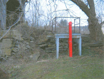
The only known fire protection system at the bridge is a dry hydrant located at the southeast corner. Three (3) fire detection/protection systems are generally used for covered bridges; fire retardant coating (NOCHAR/Poloseal), fire detection system (Protectowire) and a dry deluge sprinkler system.
A fire-retardant coating, such as "NOCHAR", can be used to protect the bridge from fire. This coating works by Dry Hydrant raising the f1ashpoint of the wood and therefore making it difficult to start a fire. The coating is available in colored and clear versions that are applied to the wood by brush or spray. The coating does not affect the strength of the wood.
If a fire is started, it is advantageous to notify the local fire department as soon as possible. The "Protectowire" system works by running a small wire through key locations in the bridge. If a rapid rise in temperature is detected or if a wire is cut, the system alerts the local mutual aid or fire department. This advanced warning can greatly reduce fire damage to a bridge and hopefully prevent the fire from making the bridge a total loss. A deluge sprinkler system is not recommended for this bridge since it is relatively short and water can be directed to the center of the bridge from either end.
For the purposes of this study, we have assumed that the NOCHAR and protectowire systems will be used on the bridge. We recommend that the Town, specifically the fire chief, make the final decision on which systems should be used on this bridge.
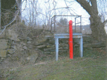
Dry Hydrant
10. LIGHTING/UTILITIES
There is no lighting present on the bridge or at the immediate approaches. Lighting can be an effective means to deter vandalism and improve visibility at night. The decision to add lighting to the bridge should be made by the Town. For this study, the cost of adding interior lighting to the bridge has not been included in the cost estimate in Appendix B. Since there is a residence very close to the bridge, if desired, interior lighting could be added and would be high-pressure sodium lights controlled by photocells. This type of lighting provides a light brown color and is the type preferred by state historic agencies.
The only known utilities within the project limits are overhead utility lines that cross Black Creek downstream (north) of the bridge. The lines are located a sufficient distance from the bridge that we do not anticipate any impacts to them fro this project.
11. ARCHEOLOGICAL RESOURCE ASSESSMENT
HTA retained Hartgen Archeological Associates, Inc. (HAA) to perform an Archeological Resource Assessment (ARA) at the project site. A complete copy of their report is included in Appendix E. Please note that the location (directions) used by HAA vary from those used by HTA and shown in Appendix C, Figure 1. We have referred to the abutments as east and west with the downstream wingwalls called the north wingwalls and the upstream wingwalls called the south wingwalls. The directions refer to the HT A nomenclature
In summary, HAA concluded the following:
- No further archeological investigation is recommended for the southwest and northeast corners of the bridge.
- Further archeological investigation is recommended at the northwest corner (former mill area) of the bridge. The investigations will consist of shovel tests in the proposed impact area.
- Further archeological investigation is recommended at the southeast corner (near dry hydrant) of the bridge if substantial impacts are made to the adjacent lawn area. The investigations will consist of shovel tests in the proposed impact area.
The only known and identified historical resource within the project limits is at the northwest corner of the bridge where a concrete portion of a former mill complex foundation serves as a wingwall. The only proposed work to the wingwall is partial depth concrete repairs where scour has occurred. The environmental resources in the area will be identified during the conceptual phase of the project.
12. ESTIMATE OF COST
An estimate of cost was prepared for this project using the "Estimator" software and past HT A and VTrans covered bridge bid data. The estimate of cost is included in Appendix B and includes the following major items:
- Remove and replace the existing metal roof with a new standing seam metal roof.
- Remove and replace deteriorated bridge members including:
- Roof boards
- Roof rafters
- Rafter support beam
- Crossbeams
- Truss bottom chord members
- Floor beams, stringers and decking (entire deck)
- Siding
- Bed timbers
- Lower lateral bracing
- Install new timber upper lateral bracing.
- Install new timber curb in the bridge.
- Realign the bridge trusses to eliminate rack in the trusses.
- Reconstruct the southeast wingwall.
- Replace the northeast wingwall with a new concrete wingwall.
- Reconstruct the east abutment where stones are missing.
- Repoint the west abutment.
- Make concrete repairs to the northwest wingwall.
- Install a protectowire system.
- Apply fire retardant coating and fungicide to the bridge.
- Install steel backed timber guardrail at the four (4) corners of the bridge.
- Replace/reconstruct the abutment backwalls.
- Pave 50' of approach pavement at each end of the bridge
The total estimated cost of all recommended work items is approximately $477,750.00 including 5% for contingences. A complete breakdown of this estimate is included in Appendix B.
13. CONCLUSIONS
The East Fairfield Covered Bridge was built around 1865 and remained in service until 1991 when it closed due to the poor condition of the lower chords. The bridge components above the deck level are generally in fair to good condition, the exception being the rafter support beam which is rotted and broken in several locations. The truss bottom chords are in poor condition with vertical sag and rot in multiple locations. The west substructure is in good condition while the east is in poor condition. The east substructure has two failed wingwalls and a portion of the breastwall stones are missing.
The East Fairfield Covered Bridge was load rated to determine its capacity to support an H6 (6 ton) live load. A live load capacity goal of H6 (6 tons) was used for this study due to the location of the bridge and the short unposted detour. Our rating assumes replacement of deteriorated bridge members, new decking and new bottom chords of each truss and supplemental members added to the truss end diagonals. It was determined that the existing truss has a live load capacity of approximately H5.7 (5.7 tons) at inventory limited by the truss vertical capacity and the floor system has a capacity of H5.4 (5.4 tons) at inventory.
Additional items are discussed in this report and recommended for the bridge include a new standing seam metal roof; new siding; replacement of deteriorated bridge members; fire protection, substructure repairs and replacements, bridge approach railing and lateral bracing; paving of the bridge approaches; and realignment of the trusses. The total estimated cost of all recommended work items is approximately $477,750.00 including 5% for contingences.
Appendices
APPENDIX A - Wood Species ID Report
Memorandum
Date: January 25, 2006
To: Sean James, P.E.
Project Manager
Hoyle, Tanner & Associates
150 Dow Street
Manchester, NH 03101
From: Doug Gardner
Professor of Wood Science
AEWC Center
Subject: Identification of 15 bridge timber wood samples from Bath Village Covered Bridge, E. Fairfield Covered Bridge and Hectorville Covered Bridge.
Following are my findings relative to the identification of the bridge timber wood species samples you sent to me on January 20,2006. I relied on my background in wood identification, and the Key to Gross Identification found in the Textbook of Wood Technology, 4th Edition by Panshin and De Zeeuw (ISBN 0-07-048441-4) in making my evaluations. Identification of the wood samples was made using a 10x hand lens.
Samples Identified
A summary of the wood species identified are listed in Table 1 along with comments related to the nature of the samples. More details about each sample are described below.
Table 1. Summary of wood species identified comprising wooden bridge members
| Sample Label | Wood Species | Comments |
| Hutchins C B Deck | Eastern hemlock | |
| Hutchins C B Chord | Eastern hemlock | Cubical brown rot decay |
| Hutchins C B Trunnel | Hard Maple | Insect attack (holes) |
| Hutchins C B Lattice | Spruce | |
| East Fairfield C B Floor Beam | Fir/Hemlock | Superficial insect attack |
| East Fairfield C B Deck | Eastern Hemlock | Brittle |
| East Fairfield C B Rafter | Spruce/Fir | Slow growth> 40 rings per 1/2 inch |
| East Fairfield C B Chord | Spruce | |
| East Fairfield C B Stringer | Eastern Hemlock | |
| Bath Village Bridge -Old Floor Beam | Eastern Hemlock | |
| Bath Village Bridge - Diagonal | Spruce | Creosote Treated |
| Bath Village Bridge - Deck | Spruce | |
| Bath Village Bridge - Chord | Spruce/Fir | Creosote Treated |
| Bath Village Bridge - Trunnel | White Oak | |
| Bath Village Bridge - New Floor Beam | Hemlock | Creosote Treated |
Wood species in italics are best estimations based on nature of samples.
- Hutchins C B Deck: Eastern Hemlock (Tsuga canadensis): wood tended to be brittle and exhibited an abrupt transition from earlywood to latewood in the growth increments.
- Hutchins C B Chord: Eastern Hemlock (Tsuga canadensis): wood tended to be brittle and exhibited an abrupt transition from earlywood to latewood in the growth increments. Sample also exhibited signs of cubical brown rot wood decay.
- Hutchins C B Trunnel: Hard Maple (Acer saccharinum): wood was diffuse porous hardwood. Outer margin of growth ring was dark brown in color. Wood had some signs of insect attack (holes 1/16th inch in diameter). Possibly powder post beetle attack.
- Hutchins C B Lattice Spruce (Picea spp.). wood yellowish-white-brown and contains resin canals, exhibits a gradual transition between the earlywood and latewood in the growth increment.
- East Fairfield C B Floor Beam: Either Eastern Hemlock (Tsuga canadensis) or Fir (Abies spp.): wood did not contain resin canals and the transition from earlywood to latewood tended to be semi abrupt which is characteristic of both species.
- East Fairfield C B Deck: Eastern Hemlock (Tsuga canadensis): wood tended to be brittle and exhibited an abrupt transition from earlywood to latewood in the growth increments.
- East Fairfield C B Rafter: Either Spruce (Picea spp.) or Fir (Abies spp.): the slow growth of this sample (greater than 40 rings per 12 inch) precluded positive identification. The transition from earlywood to latewood appeared to be gradual and this is a characteristic of both species.
- East Fairfield C B Chord: Spruce (Picea spp.). wood yellowish-white-brown and contains resin canals, exhibits a gradual transition between the earlywood and latewood in the growth increment.
- East Fairfield C B Stringer: Eastern Hemlock (Tsuga canadensis): wood tended to be brittle and exhibited an abrupt transition from earlywood to latewood in the growth increments.
- Bath Village Bridge - Old Floor Beam: Eastern Hemlock (Tsuga canadensis): wood tended to be brittle and exhibited an abrupt transition from earlywood to latewood in the growth increments.
- Bath Village Bridge - Diagonal: Spruce (Picea spp.). wood contains resin canals, exhibits a gradual transition between the earlywood and latewood in the growth increment. Sample was treated with creosote.
- Bath Village Bridge - Deck: Spruce (Picea spp.). wood yellowish-white-brown and contains resin canals, exhibits a gradual transition between the earlywood and latewood in the growth increment.
- Bath Village Bridge - Chord: Either Spruce (Picea spp.) or Fir (Abies spp.): This sample was creosote treated and the small sample size precluded positive identification. The transition from earlywood to latewood appeared to be gradual and this is a characteristic of both species.
- Bath Village Bridge - Trunnel: White Oak (Quercus spp.): Ring porous hardwood with the earlywood vessels containing tyloses.
- Bath Village Bridge - New Floor Beam: Most likely Eastern Hemlock (Tsuga canadensis): wood tended to be brittle and exhibited an abrupt transition from earlywood to latewood in the growth increments. This sample was completely saturated with creosote which precluded positive identification.
My consulting fee is $50 per sample, so the cost for this wood sample identification is $750.00. Payment can be made to:
Douglas J. Gardner
484 Day Road
Brewer, ME 04412
APPENDIX B - Estimate of Cost
Estimate
Estimated Cost: $455,500.00
Contingency: 5.00%
Estimated Total: $477,750.00
East Fairfield Covered Bridge, Fairfield, VT - Fairfield BHO 1448(32) Bridge No. 41
Town Highway No. 42
Letting Date: 08/01/06
Spec Year: 01
Unit System: E
Work Type: COVERED BRIDGE REHABILITATION
Highway Type: LOCAL
Urban/Rural Type: RURAL
Season: CONSTRUCTION SEASON BIDS (4/15 - 10/15)
County: FRANKLIN COUNTY
Prepared by HTA on 05/02/06
Estimate, Group 0001: Roadway - Total: $68,130.00
| Description | Quantity/Units | Unit Price | Extension |
| Clearing and Grubbing | 1.000 LS | $2,000.00 | $2,000.00 |
| Common Excavation | 40.000 CY | $20.00 | $800.00 |
| Subbase of gravel | 40.000 CY | $40.00 | $1,600.00 |
| Bituminous Concrete Pavement | 50.000 TON | $110.00 | $5,500.00 |
| Bridge Approach Railing | 180.000 LF | $130.00 | $23,400.00 |
| All Purpose Excavator Rental, Type 1 | 5.000 HR | $75.00 | $375.00 |
| Mobilization | 1.000 LS | $31,045.00 | $31,045.00 |
| Geotextile for Silt Fence | 100.000 SY | $8.00 | $800.00 |
| Haybales for Erosion Control | 300.00 EACH | $7.00 | $2,100.00 |
| Seed | 10.000 LB | $6.00 | $60.00 |
| Fertilizer | 5.000 LB | $10.00 | $50.00 |
| Topsoil | 10.000 CY | $40.00 | $400.00 |
Estimate, Group 0002: Superstructure - Total: $357,370.00
| Description | Quantity/Units | Unit Price | Extension |
| Structure Excavation | 30.000 CY | $30.00 | $900.00 |
| Granular Backfill for Structures | 30.000 CY | $50.00 | $1,500.00 |
| Concrete Class B | 10.000 CY | $750.00 | $7,500.00 |
| Shoring Superstructure | 1.000 LS | $55,000.00 | $50,000.00 |
| Reinforcing Steel | 2,500.000 LB | $3.00 | $7,500.00 |
| Drilling and Grouting Dowels | 70.000 LF | $20.00 | $1,400.00 |
| Epoxy Coated Reinforcing Steel | 550.000 LB | $4.00 | $2,200.00 |
| Strucural Painting | 1.000 LS | $20,000.00 | $20,000.00 |
| Containment & Environmental Protection Field | 1.000 LS | $5,000.00 | $5,000.00 |
| Water Repellent | 10.000 GAL | $50.00 | $500.00 |
| Structural Lumber and Timber - Untreated (roof boards) | 0.500 MFBM | $8,000.00 | $4,000.00 |
| Structural Lumber and Timber - Untreated (rafters, et al) | 0.400 MFBM | $9,000.00 | $3,600.00 |
| Structural Lumber and Timber - Untreated (Top Lateral X-Bracing) | 1.100 MFMB | $15,000 | $16,500.00 |
| Structural Lumber and Timber - Untreated (bed timbers/lower lateral bracing) | 0.200 MFBM | $7,000.00 | $1,400.00 |
| Structural Lumber and Timber - Untreated (Stringers) | 4.000 MFBM | $9,000.00 | $36,000.00 |
| Structural Lumber and Timber - Untreated (floor beams) | 0.400 MFBM | $9,000.00 | $3,600.00 |
| 340 522.20 Structural Lumber and Timber - Untreated (truss bottom chord) | 2.200 MFBM | $9,000.00 | $39,600.00 |
| Structural Lumber and Timber - Untreated (siding supports) | 0.200 MFBM | $7,000.00 | $1,400.00 |
| Structural Lumber and Timber - Untreated (misc. repairs) | 1.000 LS | $10,000.00 | $10,000.00 |
| Structural Lumber and Timber - Untreated (sawn decking) | 3.800 MFBM | $7,000.00 | $26,600.00 |
| Structural Lumber and Timber - Untreated (wood curbing) | 1.100 MFBM | $7,000.00 | $7,700.00 |
| Non-strutural Lumber-Untreated (siding) | 1.600 MFBM | $6,000.00 | $9,600.00 |
| Partial Removal of Structure | 1.000 LS | $15,000.00 | $15,000.00 |
| Repair of Concrete Substructure Surface Class II | 12.000 SY | $1,000.00 | $12,000.00 |
| Overhead and Verticle Concrete Repair Material | 10.000 CF | $1,000.00 | $10,000.00 |
| Repointing Masonry | 25.000 SY | $130.00 | $3,250.00 |
| Metal Roofing | 1,500,000.000 SF | $10.00 | $15,000.00 |
| Traffic Signs, Type A | 62.000 SF | $10.00 | $620.00 |
| Street Lighting (protectowire) | 1.000 LS | $8,000.00 | $8,000.00 |
| Wingwall Reconstruction | 1.000 LS | $12,000.00 | $12,000.00 |
| Wingwall Reconstruction (Mod.) | 1.000 LS | $20,000.00 | $20,000.00 |
Estimate, Group 0003: Full Construction Engineering Items - Total: $29,500.00
| Description | Quantity/Units | Unit Price | Extension |
| Temporary Traffic Barrier | 40.000 LF | $50.00 | $2,000.00 |
| Field Office-Engineers | 1.000 LS | $20,000.00 | $20,000.00 |
| Field Office-Soils & Materials | 1.000 LS | $3,000.00 | $3,000.00 |
| Testing Equipment - Concrete | 1.000 LS | $2,000.00 | $2,000.00 |
| Testing Equipment - Bituminous | 1.000 LS | $2,000.00 | $2,000.00 |
| Field Office-Telephone | 1.000 LS | $500.00 | $500.00 |
APPENDIX C
Plan, Truss, and Cross Section Drawings
Plan View of Existing Conditions
North Truss
South Truss
Typical Portal Sections
APPENDIX D
VTrans Preliminary Hydraulic Study
VT AGENCY OF TRANSPORTATION
PROGRAM DEVELOPMENT DIVISION
HYDRAULICS UNIT
| TO: | John Weaver, Structures Project Manager |
| FROM: | Nick Wark, Civil Engineer III |
| DATE: | November 7, 2005 |
| SUBJECT: | Fairfield BHO 1448(32) - TH49 Br50 |
We have completed our preliminary hydraulic study for the above referenced site, and offer the following information for your use:
The existing 'Covered bridge was built in 1865. It is 67' long with a clear span of 59'. The bridge is built on laid-up stone abutments that have been repaired with concrete over the years. There are some large voids visible in the abutments. There is a large bend in the river just downstream of the bridge and an old miil dam that controls water sUlface elevations.
Our calculations show that the existing bridge is hydraulically adequate. The Q25 water surface elevation is 381.4' providing'1.6' offreeboard. The QI00 water surface elevation is 382.4'.
A USGS Level IT Scour Analysis was done for this structure 1998. The results show 3.1' of contraction ~cour at Q500. The foundation below the abutments is unknown, ifit is found that the abutments are still stable, repair is an option. If new abutments are constructed they should , be founded at least 6' below the streambed).or on ledge to prevent undermining.
Please contact us if you have any questions or if we may be of further assistance.
NJW
cc: Hydraulics Project File via MJT
Hydrauhcs ehrono File
APPENDIX E
Archeological Resource Assessment
Hartgen
ARCHEOLOGICAL ASSOCIATES, INC.
Cultural Resource Specialists
PO BOX 81 PUTNEY, VERMONT 05346
PHONE: (802) 387-6020 FAX: (802) 387-8524
Mr. Sean James, P.E.
Hoyle Tanner & Assoc., Inc
150 Dow Street
Manchester, NH 03101
RE: Archeological Resource Assessment
Fairfield BHO 1448 (32)
East Fairfield Covered Bridge Renovations
Town of Fairfield, Franklin County, VT
March 27, 2006
Dear Sean,
Hartgen Archeological Associates, Inc. (HAA, Inc.) recently completed a site visit and conducted research for an Archeological Resource Assessment (ARA) for the proposed East Fairfield Covered Bridge (Fairfield BHO 1448(32)) Renovation project in the Village of East Fairfield, Franklin County, Vermont. The East Fairfield Covered Bridge is constructed over Black Creek, and is located on Bridge Street (TH 49) between Route 38 to the northeast and TH 50 to the south (Figure 1). The Area of Potential Effect (APE) for the proposed bridge project is restricted to an area measuring approximately 250 feet (76 m) on either side of the bridge, north and south, and along the east and west sides ofTH 49.
The Archeological Resource Assessment provides the information necessary to assess the potential for National Register Listed or Eligible archeological sites to be effected by the project. The ARA identifies potential areas of historic or pre contact sensitivity. The research and report conforms to the guidelines for archeological studies under Section 106 of the National Historic Preservation Act, as defined by the Vermont Division for Historic Preservation (VDHP 2002), the Vermont Historic Preservation Act, and Act 250 (Peebles 1989). This letter report presents the results ofthe research and site visit and the ARA. Site reconnaissance was conducted by HAA, Inc. archeologist on March 17, 2006. The archeological report was written by project director, Elise Manning-Sterling and edited by principal investigator, Karen S. Hartgen. Graphics were prepared by Bruce B. Sterling.
CERTIFIED DBE/WBE IN NEW YORK, NEW JERSEY, MAINE, NEW HAMPSHIRE, VERMONT, MASSACHUSETTS, CONNECTICUT, PENNSYLVANIA, AND NEW YORK CITY AGENCIES
TELEPHONE: (802) 387-6020
Email: ems@hartgen.com
FAX: (802) 387-8524
ARA, E. Fairfield Covered Bridge Renovations, Fairfield BHO 1448 (32), Franklin Co., VT
Background Research
The archeological investigation entailed research into the historic and precontact use of the project vicinity and its environs and the investigation of the archeological site files. The literature review for historic and precontact sites consisted of:
- Research at the Vermont Division for Historic Preservation (VDHP) including:
- archeological site files for sites within or adjacent to the project area
- archeological surveys conducted on or near the project area
- town and environmental project files
- National Register listed archeological sites and standing structures located within or adjacent to the project area
- archeological sites being considered for the National Register
- Research at the Vermont State Library and the Vermont Historical Society including:
- historic maps and
- review local histories of the project vicinity
Precontact Sites and Sensitivity
East Fairfield is located in the narrow Black Creek valley in an area of low hills situated approximately 11 miles (17.5 km) east of St. Albans Bay on Lake Champlain, and located 6.5 miles (10 km) south of the Missisquoi River Valley. The East Fairfield Covered Bridge is located near falls along the Black Creek which were utilized and altered (through the creation of mill ponds) during the 19th century.
Research at the VDHP revealed that there are no recorded archeological sites located within the project area or in the near vicinity. The dearth of recorded sites suggests that the area's use during pre contact times was limited. However, there are other factors which may account for this phenomenon, including the paucity of archeological surveys conducted in this area, the presence of low density precontact sites and/or seasonal or intermittent camp sites which were not used intensively.
The VDHP predictive model form was used to determine the pre contact sensitivity of the project area (Appendix A). An evaluation of the project area produced a rating of 20, indicating that the general area has a low archeological sensitivity. However, the presence of level terrain in areas located on the southwest and northeast comers of the bridge directly adjacent to Black Creek and near the falls have an archeological sensitivity for the presence of precontact sites. Limited archeological testing would determine whether any intact archaeological resources are present in these two areas.
Historic Archeological Sites and Sensitivity
The background research revealed that no recorded archeological sites or cemeteries are located within the project area limits. The historic map research revealed that the bridge is situated over a historic mill pond associated with a grist mill and a saw mill which were located on the south side of the Black Creek west of the bridge.
National Register Sites
The East Fairfield Covered Bridge c.1865 is located on the National Register of Historic Places. The National Register nomination form notes that;
The covered bridge at East Fairfield village is the only covered wood bridge remaining in the town of Fairfield. Built about 1865, the bridge and mill pond which it crosses are the only surviving elements of an early industrial complex beside the falls of Black Creek. .... The East Fairfield Covered Bridge consists of a single span supported by two flanking timber queenpost trusses. Each truss incorporates iron suspension rods which extend from upper apexes formed by the diagonal members to the bottom chords ..... The East Fairfield Bridge is 68 feet long overall and 16.5 feet wide. The bridge has a 13 foot roadway; its wood floor consists of planks laid flat and perpendicular to the trusses, beginning three feet inside the south portal.
In 1995, a study was conducted for the East Fairfield Covered Bridge by McFarland-Johnson, Inc. for the State of Vermont Agency of Transportation as part of a long-range plan for the preservation of historic covered bridges of Vermont (McFarland-Johnson, Inc. 1995). To provide for the preservation of the East Fairfield Bridge, this study concluded that it should be closed to vehicular traffic, and necessary maintenance provided to avoid collapse prior to a course of extensive stabilization.
Vermont State Register Sites
There are ten structures in the Village of East Fairfield which are listed on the Vermont State Register, two of which are located within or adjacent to the project area.
- The East Fairfield Covered Bridge - built c. 1865.
- The Marshall True House (Ritchie Hotel) c. 1830. This was one of two hotels which provided services for the thriving industrial and commercial enterprises in the town of East Fairfield during the early and mid-19th century. This structure is located approximately 300 feet (92 m) southeast of the East Fairfield Covered Bridge, located on the east side of the road.
Historic Maps and Sensitivity
The 1858 Walling (Figure 2) and 1871 Beers (Figure 3) maps depict the village of East Fairfield and shows details of the project area. In 1858, the road (Bridge Street) was well established, with a store located northwest of the bridge and a residence situated northeast of the bridge. On the south side of the bridge, a mill complex was established west of the road which included a grist mill, a saw mill, and a store. A structure, the possible residence of H. S. Read, is shown located directly southeast of the bridge. The hotel is depicted further to the south on the east side of the road. The map does not indicate what type of bridge was present then.
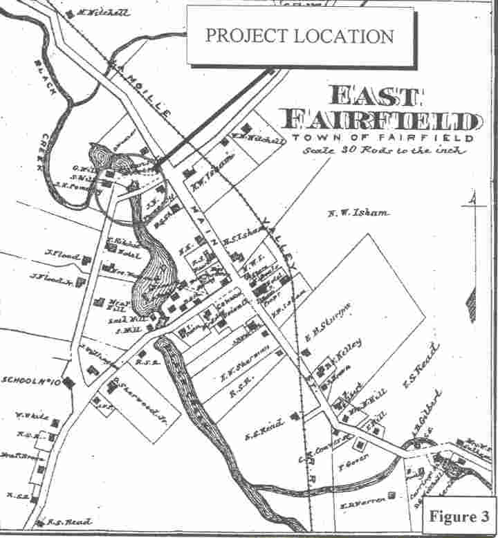
The 1871 Beers map demonstrates that the village and town had grown extensively over the previous decade, with many new roads established, and the construction of new residences, businesses, and mill complexes. Within the project area, the map shows a bridge extending over a mill pond on the Black Creek. This is presumably the East Fairfield Covered Bridge which was constructed c. 1865, although it is not specifically identified as such on the Beers map. Southwest of the bridge is the J.N. Pomeroy grist and saw mill complex. No structure is shown located on the southeast comer of the bridge as was depicted on the 1858 WaIling map. It is likely that this structure was removed or razed, possibly when there was expansion of the mill complex and mill ponds. The T. Ritchie Hotel is shown located further south of the bridge, situated on the east side of the road. On the north side of Black Creek, located on the east side of the road is the J.N. Pomeroy residence which is still extant. Northwest of the bridge, the J. C. Davis & Co. Store and Post Office was situated on the corner of Main and Bridge Streets.
Project Area Site Reconnaissance and Recommendations
On March 17, 2006, a HAA, Inc. archeologist conducted a walkover of the project area in order to identify historic features, areas of archeological sensitivity, prior disturbance, excessive wetness, or excessive slope. The APE for the proposed bridge project is restricted to an area measuring approximately 250 feet (76 m) on either side of the bridge, north and south, and along the east and west sides of TH 49. At this time, there are no detailed project designs from which specific impact areas can be defined. Therefore, general recommendations are provided which pertain to the four areas located at each comer of the covered bridge.
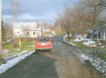
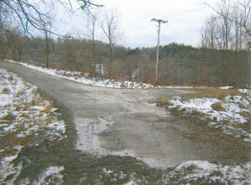
The area southeast of the bridge is characterized by a moderate to steep slope which inclines from the road downward to the Black Creek to the northeast (Photo 1). The T. Ritchie Hotel is located several hundred feet south of the bridge, outside of the Area of Potential Effect. The precontact archeological sensitivity of the area southeast of the bridge is considered to be low. No further archeological investigation is recommended for this area.
The area southwest of the bridge is a relatively flat terrace overlooking the Black Creek and mill pond. The area is primarily overgrown with low brush, and contains a short modem drive/turn- around area (Photo 2). Based on historic maps, this area was part of the J.N. Pomeroy mill complex, and has archeological sensitivity for historic resources. Portions of this terrace which were undisturbed during the historic use of this area would have potential for the presence of precontact material. It is recommended that archeological testing be conducted in this area prior to construction or stabilization. Recommended archeological investigation would consist of the excavation of several shovel tests in the proposed impact area.
The area northeast of the bridge is a residential parcel which contains a 19th -century house (J.N. Pomeroy residence)(Photo 3). The lawn is level to gently sloping downward toward the Black Creek At its northern end, the bridge is raised on a high abutment above the surrounding lawn and ground surface. The grass lawn area is considered to have a moderate archeological sensitivity for the presence of precontact resources. It is recommended that archeological testing be conducted if there will be substantial impacts to the adjacent lawn area. Recommended archeological investigation would consist of the excavation of several shovel tests in the proposed impact area.
The area northwest of the bridge is a narrow residential parcel which contains a 19th-century residence (Photo 4). The area directly northwest of the bridge is a lawn area which slopes downward to the Black Creek. Because of the moderate slope, this area is considered to have a low archeological sensitivity for precontact resources. No further archeological investigation is recommended for this area.
Sincerely,
Elise H. Manning-Sterling
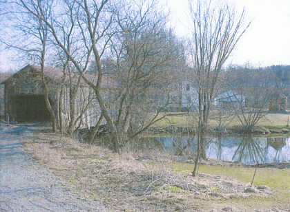
Photo 1. View of project area southeast of the bridge. View is to the northeast.
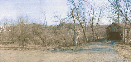
Photo 2. View of the project area southwest of the bridge. View is to the north.
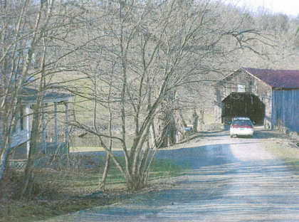
Photo 3. View of the project area northeast of the bridge. View is to the south
Photo 4. View of the project area northwest of the bridge. View is to the north.
Bibliography
| Beers, F. W. | 1871 Atlas of Franklin and Grand Isle Counties, Vermont. F.W. Beers, New York. |
| McFarland-Johnson, Inc. | 1995 Covered Bridge Study at East Fairfield Bridge, Bridge No. 50 Town Highway 49, Town of Fairfield Franklin County. Prepared for the State of Vermont Agency of Transportation. Report on file at the Vermont Division for Historic Preservation, Montpelier, Vermont. |
| Peebles, Giovanna | 1989 Guidelines for Archeological Studies in Vermont Vermont Division for Historic Preservation, Montpelier, Vermont. |
| United States Geological Survey (USGS) | 1986 Bakersfield, Vermont 7.5' Topographic Quadrangle. United States Geological Survey, Reston, Virginia. |
| Vermont Division for Historic Preservation | 2002 The Vermont State Historic Preservation Office's Guidelines for Conducting Archeology in Vermont. Vermont Division for Historic Preservation, Montpelier, Vermont. |
| Walling, H.P. | 1857 Map of Franklin and Grand Isle Counties, Vermont. Baker & Tilden: New York. |