Hammond Bridge Called Unsafe for Pedestrian Traffic
by Ed Barna, Rutland Herald Correspondent

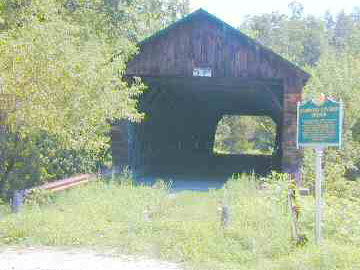
Pittsford, August 17, 2003 - The Hammond Covered Bridge, [WGN VT- 11-05] overdue for repairs, is too dangerous even for pedestrian traffic, according to state historic preservation officials.
The bridge is part of a state-owned site along Kendall Hill Road (known as the "truck route" for the regular passage of trucks to and from OMYA in Florence). It has been closed to vehicle traffic for more than a decade, but not to foot traffic.
According to covered bridge builder Jan Lewandoski of Stannard, a wooden bridge's own dead load is the heaviest weight it has to carry, and is always its biggest problem.
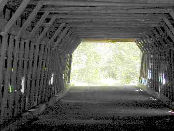
Through the years, the Hammond bridge has been subject to what engineers call "creep," a gradual increase in its downward deflection. Well-maintained covered bridges compensate with a slight upward bend, known as camber, but this 139-foot bridge has lost its camber entirely and is visibly sagging.
Also, according to Eric Gilbertson, deputy director of the Division for Historic Preservation, the bridge has also developed a twist. "Snaky" was his word to describe the shape of the 161-year-old structure.
"There are holes in the floor," added Margaret Armitage, a member of the Pittsford Historical Society.
One reason for its condition might have to do with its history. During the 1927 flood, the bridge floated downstream about a mile to the Pomainville farm. It was floated on barrels back to its original crossing and put back into use.
Gilbertson and John Dumville, the state's historic sites coordinator, both said they have tried for two sessions to get the Legislature to approve funds for stabilizing and then rehabilitating the Hammond bridge.
But now it is in such bad shape, they said, that a heavy snow load next winter--or a large group of tourists tramping across--could send it into the river.
Asked how many people he thought the bridge could safely take, Gilbert's first answer was "none."
He then added, "I couldn't say absolutely."
The Hammond site is a likely tour bus stop because it has a large parking area, a state interpretive sign, and it leads to a historic trail on the other side of Otter Creek. The trail goes toward the Revolutionary War site of the former Fort Mott and the shallow area--"Pitt's Ford," General Jeffrey Amherst named it--where troops could cross before there were any bridges.
As for the Hammond bridge, Gilbert said, "I thought we had closed that off. People weren't supposed to go on it."
But Armitage said an inspection Friday showed only a chain between two posts meant to keep vehicles off.
"No signs saying 'No Trespassing' or 'No Pedestrians,'" she said. "It hasn't changed at all."

"only a chain between two posts"
Photo by Joe Nelson
Aug. 19, 2003

Note extreme racking
Photo by Joe Nelson
Aug. 19, 2003
[This article first appeared in the Rutland Herald, Rutland, Vt., Aug. 17, 2003. Ed Barna is a member of the Vermont Covered Bridge Society and author of the book Covered Bridges of Vermont Countryman Press - Ed.]
