The Keating's Tour California
Part I
Hi Folks,
Liz and I left for California on May 28, flying to Los Angeles, where we met friends for dinner. We had reserved a compact car at National Car Rental. We completed paperwork at the counter and were told to go to the parking lot and pick out any compact. Imagine our surprise when we saw only SUVs and minivans in the "compact" car row. I asked a passing employee and he said that we could have a minivan or SUV at no extra charge if it was parked in the compact row. We didn't like this idea, since that would double our gas bill. Just then another employee pulled up with a Chevrolet Cobalt, fresh from the car wash. We took that one. When we returned home, I totaled our gas receipts--a little over $320. I suspect that I saved about $320 by passing on a minivan/SUV.
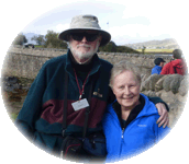
On Thursday the 29th, we headed north driving part of the way on the scenic coast road, California 1. The seal pictures are dated the 28th because my camera somehow lost a day and I did not discover it until about June 5. Liz now has her own digital camera, a Canon A560. At one point we passed thru a huge field of oil derricks. I thought of a herd of mechanical giraffes, with their long necks constantly dipping and rising. We also noticed tumbleweeds piled up against the fence for several miles.
The first picture is of a yearling seal coming ashore. The second is of a male and a female. The male had climbed atop the female with amorous intentions, but the female got out from under, turned around, lifted up her head and started barking at him, probably-"Not now! I have a headache!" These pictures are taken from the Northern Elephant Seal viewpoint, Point Piedras Blancas.
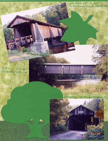
The next pictures are of the covered bridge and covered bridge sign at the Roaring Camp & Big Trees Narrow gauge RR. The RR has two trips, one to the boardwalk at Santa Cruz and the second, a trip up Bear Mountain. Both go through the Henry Cowell Redwoods State Park (see scan of steam engine). On the 30th we rode the mountain train and on the 31st we rode the boardwalk train. We also found time to walk a trail in the Henry Cowell State Park and persuaded a man to take our picture in front of the tallest tree in the park, also 5th tallest in the world.
Next we visited the Felton covered bridge, the tallest in the country, according to the sign. My AAA tour book also says it is the only one in the US made of redwood. There are three pictures of the Felton bridge and one of the sign. The picture with Liz shows the barriers, blocking atvs, snowmobiles and bikes. We also visited the Paradise covered bridge, located inside Masonic Paradise Park, a private development next to the state park. We asked for permission to visit it at the office.
We used Dale Travis' covered bridge website for directions, which I found thru a link on the California tourism website, but it is also on the VCBS website.
Tom
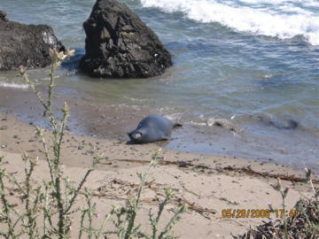
Photo by the Keatings
May 30, 2008
Photo by the Keatings
May 30, 2008
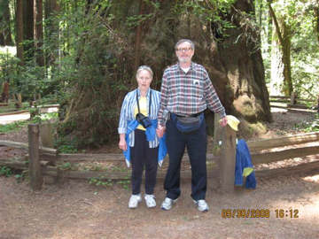
Photo by the Keatings
May 30, 2008
Tom and Liz Keating visiting tallest tree in Henry Cowell State Park
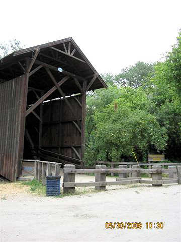
Photo by the Keatings
May 30, 2008
Felton, CA, "the tallest bridge."
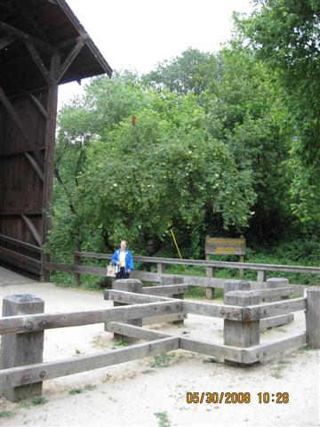
Photo by the Keatings
May 30, 2008
"The tallest bridge" with Liz.
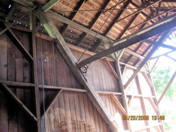
Photo by the Keatings
May 30, 2008
Felton Bridge Interior
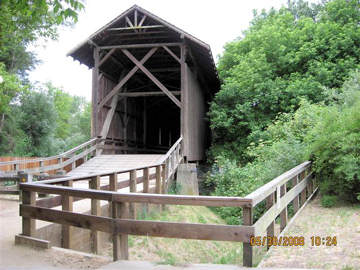
Photo by the Keatings
May 30, 2008
Felton Bridge portal view 186 feet long, it San Lorenzo R. using a Pratt variation Truss.
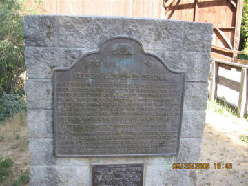
Photo by the Keatings
May 30, 2008
Felton Bridge plaque at Felton Park
Built in 1882 and believed to be the tallest covered bridge in the country it stood as the only entry to Felton for 45 years. In 1937 it was retired from active service to become a pedestrian bridge and figured prominently in many films of that period. After suffering damage in the winter storms of 1982. It was restored to its original elegance in 1987 using native materials and local talent. California Registered Landmark No. 583.
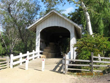
Photo by the Keatings
May 30, 2008
Built in 1969, 36 feet in length, it crosses Roaring Creek using a Pratt truss
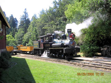
Photo by the Keatings
May 30, 2008
Roaring Creek & Big Trees Narrow Guage RR
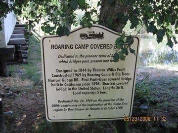
Photo by the Keatings
May 30, 2008
Roaring Camp Sign
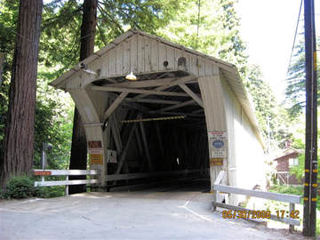
Photo by the Keatings
May 30, 2008
Paradise Park Bridge at Masonic Paradise Park. 180 feet long in two spans, crossing San Lorenzo River using Smith Truss.
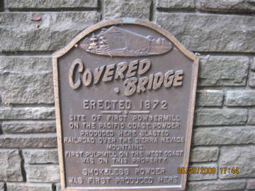
Photo by the Keatings
May 30, 2008
Site Sign
Part II
On Sunday, June 1st, we left Felton for Yosemite National Park, stopping at Knights Ferry covered bridge along the way. Knights Ferry is, at 360 ft (span length), the longest covered bridge west of the Mississippi. There is a possibility that it was deigned by Ulysses Grant, later Civil War General and President of the US. I like the picture of Liz walking thru the bridge.
The bridge is part of a complex of several historic buildings maintained by the Army Corps of Engineers, which was given responsibility for the bridge in a 1981 law, but did not get title to it until 1985. Upon receiving title, the Army realized that the bridge needed repairs and called upon the famous Graton covered bridge company for a thorough review of the bridge. We saw a short film in which all three of the Gratons, patriarch, Milton, son Arnold, and grandson JR were interviewed and shown working on repairing the bridge.
The visitor center is open seven days a week(we were there on a Sunday). On the day we were visiting, it was staffed by a husband and wife volunteer couple. There was a loose leaf binder book at the counter with pictures and directions to all of California's covered bridges. There was also a covered bridge exhibit in the visitor center, with a California map and pictures of several authentic cbs. Sunday afternoon we arrived in Oakhurst for our eight- night stay.
On June 2 we visited the Wawona covered bridge, see scans of sign and bridge with whitewater. I climbed down to the riverbank to get the view with the whitewater. Liz took the two front view pictures. The shuttle bus driver told us that when the park service asked for bids on repairing the bridge after flood damage, that there only a few companies with the expertise to repair it. According to signs and information at park exhibits, there have been several floods that damaged the bridge. One in 1955 did so much damage that a proposal was put forward to replace the covered bridge with a steel/concrete bridge (see collected covered bridge articles, California, on this website for more info). I have attached a flood meter sign at the Merced River Sentinel footbridge(located in the valley, over the main Merced). I didn't see any flood signs at the Wawona bridge. The Wawona bridge is one of three inside National Park units and we have now seen all three(others at Valley Gorge, Pa. and Sleeping Bear Dunes, Mich.). I purchased a National Parks Senior Pass for $10. The pass is good for as long as I live and provides free admission to almost all National Parks. If you are 62 or older I highly recommend it.
On June 3, we walked trails in the valley--see scan of Yosemite Falls. The Wawona bridge is over the South Fork of the Merced river which joins the Merced outside Yosemite Park. I actually took a raft trip on the Merced river, starting outside the park and went past the point where the South Fork joins up with the main river, on June 4. Sorry, I don't have any pictures, since my camera isn't waterproof. Our raft went thru some serious whitewater, including one spot where one of the four rafts in our group went straight up in the air and all of the passengers fell out. Our guide began giving all these orders to us--forward paddle!--Back paddle--right turn--left turn--so we could rescue people. As it turned out, all but one got back into their own raft and that one, a boy of about 9, got into a raft next to us. Our raft recovered two paddles. This was my first raft trip on a covered bridge river. Liz says that I am crazy. She stayed at the motel and did laundry.
On June 5, we rode the Yosemite Mountain Sugar Pine RR.
Afterwards we walked some trails and visited the famous Ahwahnee hotel. I took a picture of Liz at the entrance. Also, see scan of us and Half Dome from Glacier Point.
Tom
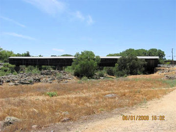
Photo by the Keatings
June 1, 2008
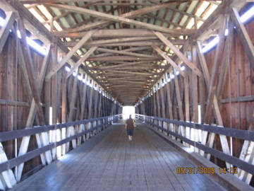
Photo by the Keatings
June 1, 2008
Knights Ferry Interior with Liz
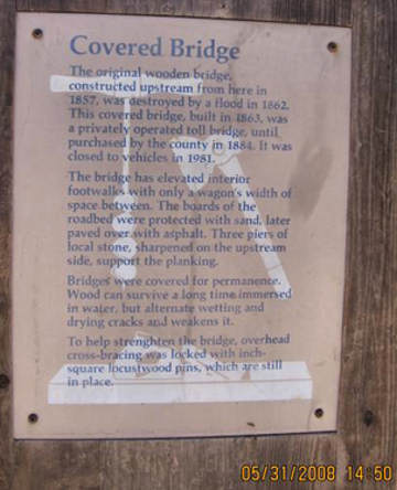
Photo by the Keatings
June 1, 2008
Knights Ferry Sign
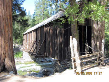
Photo by the Keatings
June 2, 2008
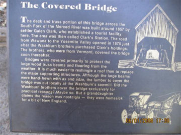
Photo by the Keatings
June 2, 2008
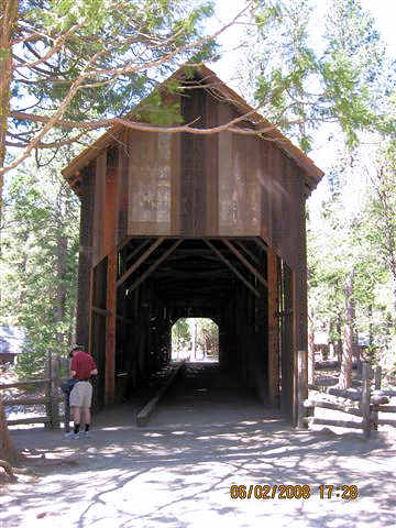
Photo by the Keatings
June 2, 2008
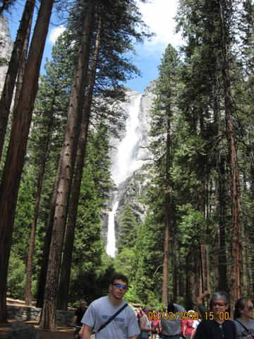
Photo by the Keatings
June 3, 2008
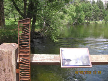
Photo by the Keatings
June 3, 2008
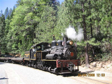
Photo by the Keatings
June 5, 2008
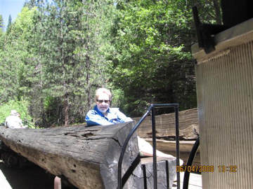
Photo by the Keatings
June 5, 2008
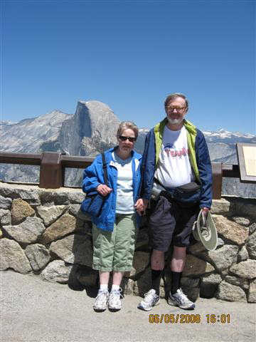
Photo by the Keatings
June 5, 2008
Part III
Hi Folks,
On June 6 we did some hiking and visited the historic Ahwahnee hotel. On June 7 we drove the Tioga road across the middle of the park through Tioga pas. There we saw a tree growing out the sold rock and another out of fractured rock, both taken from Olmstead Point. We drove to Devils Post-pile National Monument. My Senior Pass wasn't valid at Devils Post-pile, but we arrived on a free day.
On Sunday, 6-8, we drove to Railtown 1897, a California State Historic Park(see scan). The brochure mentioned that this train was a favorite of Hollywood film-makers, found in "The Unforgiven", "High Noon", "Petticoat Junction" and a "Little House on the Prairie" episode, among 50 different movies and tv shows.
After riding the train, we drove to Hetch Hetchy Valley part of Yosemite NP. This valley was the site of an epic confrontation between the city of San Francisco and the beginning environmental US movement.
There is a dam called the O'Shaughnessy Dam, on the Tuolumne River, in this valley. Back in 1906, the San Francisco earthquake was followed by an even more destructive fire, which raged out of control due to an inadequate water supply. Gifford Pinchot, who convinced President Roosevelt to start the US Forest Service, urged the President to approve San Francisco's request for a dam inside Yosemite National Park. TR's Secretary of the Interior subsequently approved the city's application, but a law had to be passed by Congress approving a land swap between the city and the US govt. John Muir, founder of the Sierra Club led the opposition.
However, the city prevailed, and the bill was signed by President Wilson in 1913. I have attached pictures of the dam, a diagram showing it and another dam just outside the park which flooded another part of the park. No dam has been built inside a US National Park since then.
We saw cars with bumper stickers:"Restore Hetch Hetchy." Two dams in the US have been taken down in the last 10 years, one on the Elwha river in Washington state and the other on the Neversink river in NY state. The Neversink river is crossed by Halls Mills covered bridge, NY-53-01. We visited this bridge in 2002 before either of us had digital cameras and I never scanned it until today. As you can see, it is part of a covered bridge scrapbook made by Liz.
She has three loose leaf binders of cbs that we have visited, mostly in the US, but some in Europe, as you know if you have read previous travelogues by me. She has compiled these three scrapbooks because she doesn't want her covered bridge photo collection discarded when she passes on. She figures that our children/grandchildren will want to keep them more than they would simple photo albums.
Tom
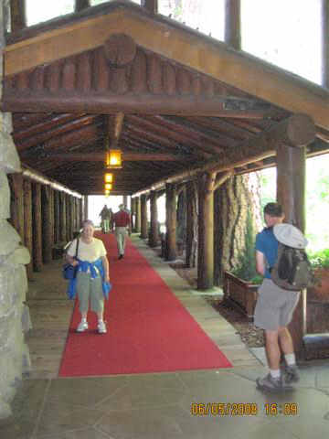
Photo by the Keatings
June 6, 2008
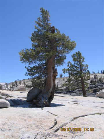
Photo by the Keatings
June 7, 2008
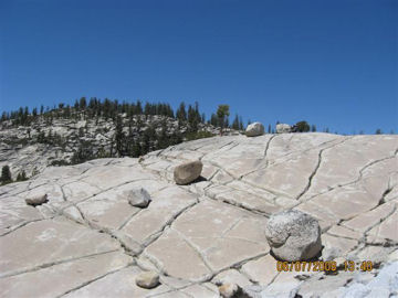
Photo by the Keatings
June 6, 2008
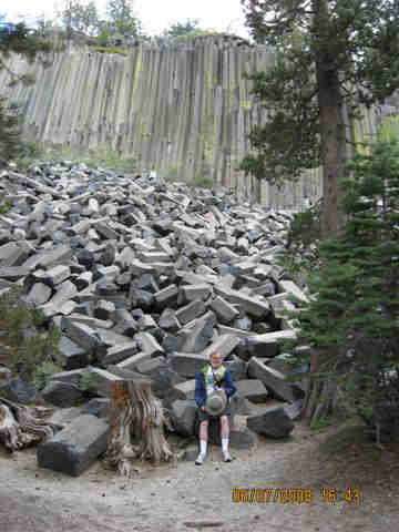
Photo by the Keatings
June 7, 2008
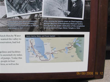
Photo by the Keatings
June 8, 2008
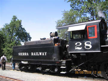
Photo by the Keatings
June 8, 2008
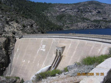
Photo by the Keatings
June 8, 2008
By Liz Keating
Part IV
Hi Folks
On Monday, June 9, we left for Stoney Creek Lodge, on the Generals Highway, between Kings Canyon and Sequoia Natioanal Parks. I have attached photos of myself on the "John Muir Rock" where he had picnics when visiting Hetch Hetchy valley, and Liz in front of Roaring River falls, both in Kings Canyon National Park
On June 10 we visited Sequoia National Park, Liz by cool sign, General Sherman tree sign, explaining that it is the largest in the world, and Liz in front of General Sherman tree.
On June 11, we drove to the southern part of Sequoia National Park and stopped at Tunnel Rock, which used to be part of the South Entrance road. I also took a picture of Liz driving our car thru the tunnel tree, which had fallen across the road.
On June 13, we flew home out of Fresno, Ca. the nearest major airport to Kings Canyon National Park. Actually, it was a regional airport, as we had to fly to San Francisco,then to Chicago, then to Buffalo. There have been several forest fires in California in the areas that we visited since we left. One closed the coastal highway near Big Sur. There have been others near Yosemite, the most recent bewteen Mariposa and the west/valley entrance to Yosemite. According to news reports, it is burning on both sides of the Merced river-- where I rafted. Power to the valley part of Yosemite has been cut off, because of the fire. On July 29, the 140 route into the valley was closed. Visibility in the valley is severely reduced.
Tom
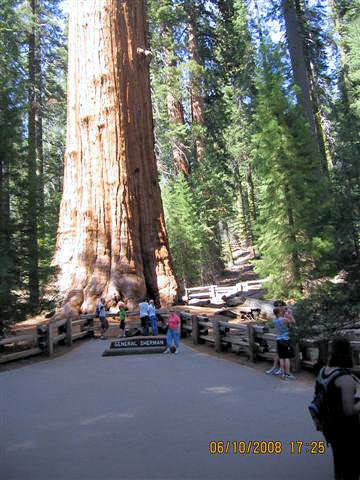
Photo by the Keatings
June 10, 2008
Liz at General Sherman Tree
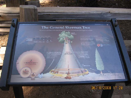
Photo by the Keatings
June 10, 2008
General Sherman Tree Sign
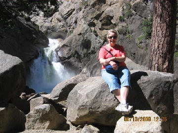
Photo by the Keatings
June 10, 2008
Liz at Roaring River Falls
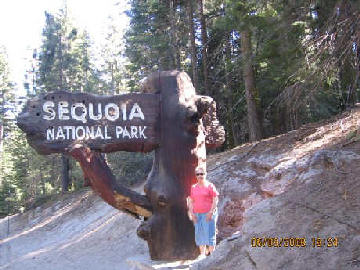
Photo by the Keatings
June 10, 2008
Liz at Sequoia National Park Sign
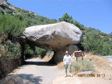
Photo by the Keatings
June 10, 2008
Liiz at Tunnel Rock
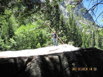
Photo by the Keatings
June 10, 2008
Tom at John Muir Rock